Exploring the wild, untouched landscapes of Sanibel and Captiva Islands just became a lot easier. The Sanibel-Captiva Conservation Foundation (SCCF) announced the launch of a new, state-of-the-art interactive preserve map designed to guide nature lovers through the islands’ public trail systems while educating the community on regional land conservation.
At the LeAneSuarezGroup, we know that the deep commitment to environmental preservation is exactly what makes our barrier islands such an extraordinary place to purchase real estate. Having world-class hiking, bird-watching, and wetland trails practically in your backyard adds unmatched lifestyle value to our local neighborhoods.
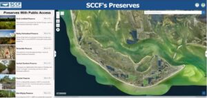
In a nutshell: The SCCF owns and manages over 2,200 acres of protected land. While most areas are strictly closed to safeguard vulnerable species, seven iconic preserves remain open to the public. The SCCF’s new digital map allows users to filter, locate, and explore these pristine trail networks.
Balancing Ecological Protection and Public Access
The scale of the SCCF’s conservation footprint is massive. The foundation outright owns more than 1,900 acres across Sanibel, Captiva, and the surrounding watershed, while managing an additional 300-plus acres of protected preserve lands.
To keep the islands’ delicate ecosystems flourishing, a vast majority of these properties are entirely closed to the public. These restricted interior zones shield fragile ecological habitats and protect rare, threatened, or endangered wildlife from human disruption. However, to foster community connection with the environment, the SCCF proudly maintains seven distinct preserves that feature maintained trail systems open for public enjoyment. These walking paths wind through a beautiful mix of low-lying interior wetlands and elevated upland hammocks.
                     SCCF LAND MANAGEMENT MATRIX

  [ TOTAL PROTECTED LAND ] ──► 2,200+ Total Acres (Owned & Managed)
  [ CLOSED RESERVES ]      ──► Off-limits to protect rare & endangered species
  [ PUBLIC SANCTUARIES ]   ──► 7 Open Preserves featuring scenic hiking trails
Features of the New Interactive Map
The newly designed digital map serves as a dual-purpose tool: it functions as a trail finder for outdoor enthusiasts and an educational repository highlighting decades of land acquisition.
When clicking through the interface, each specific preserve listing reveals rich historical and biological data points, including:
-
Public Status: Clearly indicates whether a preserve is completely open for hiking or closed for strict wildlife sanctuary purposes.
-
Acquisition History: Details the exact year the land was formally acquired by the foundation alongside its previous ownership records.
-
Property Scale: Lists the precise acreage and spatial size of the protected zone.
-
Ecosystem Profiles: Explains the specific category of coastal habitat, flora, and fauna that the tract actively safeguards.
To make exploration highly customizable, the digital application features advanced search filters. Users can dynamically sort the entire island database by historical acquisition timeframes or specific ecosystem types—giving a clear, visual look at how the foundation’s conservation footprint has expanded over the decades.
Tips for the Best Digital Mapping Experience
Because the mapping interface handles high-resolution geographic data layers, the SCCF recommends viewing the tool on a computer, laptop, or tablet screen for the most immersive experience. While the portal is fully accessible on smartphones, smaller mobile screens may experience limited formatting or compressed feature visibility.
To start mapping your next island weekend hike, pull up the Official SCCF Interactive Preserve Map. Lace up your walking shoes, pack some water, and enjoy the pristine natural beauty that makes our sanctuary islands a truly world-class home!