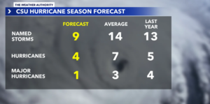
Meteorologists and coastal communities are monitoring a significantly altered tropical outlook. Researchers at Colorado State University (CSU) have issued their latest seasonal revision for the ongoing 2026 Atlantic hurricane season, further downgrading their numbers to project a final outcome that lands well below historical averages.
At the LeAneSuarezGroup, we emphasize that tracking tropical weather cycles is an important part of protecting your long-term coastal real estate investments. While a lower forecast brings peace of mind to property owners on Sanibel, Captiva, and Fort Myers Beach, maintaining standard seasonal emergency preparedness remains a necessary practice for all Florida residents.
The Updated Outlook: The revised CSU forecast now calls for a total of 9 named storms, 4 hurricanes, and 1 major hurricane basin-wide. If these numbers hold true, 2026 will go down as the quietest and least active Atlantic hurricane season in over a decade.
The Science Behind the Drop: The El Niño Factor
The primary driving mechanism behind this aggressive seasonal reduction is the rapid reinforcement of an El Niño climate pattern in the tropical Pacific. Climatologists expect this system to grow exceptionally robust as the calendar moves toward the traditional peak months of the hurricane cycle.
                    EL NIÑO METEOROLOGICAL INFLUENCE

  [ RISING PACIFIC AIR ] ──► Triggers increased storm activity across the Pacific basin.
  [ ATLANTIC SUBSIDENCE ]──► Creates widespread sinking air that suppresses storm formation.
  [ DISRUPTIVE SHEAR ]    ──► Amplifies upper-level vertical wind shear to shred disturbances.
In addition to atmospheric suppression, water temperatures across the Atlantic basin have stabilized closer to historical baselines, moving away from the extreme, red-hot thermal anomalies that fueled hyperactive tropical cycles over the past few years. As a result, CSU forecasters have calculated the probability of a major hurricane making a U.S. landfall at just 17%, a sharp drop from the long-term historical benchmark of 43%.
A Look at the Numbers: 2026 vs. Historic Benchmarks
The baseline figures for the current season are tracking well underneath standard 30-year operational averages:
| Tracking Metric | 1991–2020 Historic Average | Updated 2026 CSU Forecast |
| Named Storms | 14.4 | 9 (Includes TS Arthur) |
| Total Hurricanes | 7.2 | 4 |
| Major Hurricanes (Cat 3+) | 3.2 | 1 |
| Accumulated Cyclone Energy (ACE) | 123 | 50 (40% of typical heat energy) |
The current statistical floor for low-activity years remains 2014, a cycle that yielded only eight named storms. The year 2026 is currently pacing to sit directly adjacent to that quiet stretch. The first official system of this cycle, Tropical Storm Arthur, has already developed and dissolved, spending roughly 24 hours bringing localized rain and coastal surge to the Texas coastline in mid-June before moving inland.
The “Rule of One”: Why Preparedness Remains Unchanged
Though the statistical drops are encouraging, public safety officials and meteorologists note that seasonal averages do not dictate localized coastal impacts.
Historical archives show that inactive cycles can still produce catastrophic results if a single system develops in the right environment. The premier example remains the 1992 Atlantic hurricane season. On paper, that year was exceptionally quiet—generating only seven named storms. However, one of those few systems was Hurricane Andrew, a Category 5 storm that caused historic destruction across South Florida.
The Atlantic hurricane season runs continuously through November 30. The Tropical Meteorology Project at Colorado State University is scheduled to publish its next comprehensive statistical revision on August 5, providing a highly refined look at environmental conditions just as the historical peak of the season arrives. Secure your window shutters, keep your emergency supplies stocked, and enjoy a safer, quieter summer season in paradise!